
![]()
Introduction
With the growing impacts of climate change, accelerated socioeconomic development, and increasing population, demands for water, energy and food will keep rising – putting ecosystems at risk. To address this, it is crucial to consider the synergies and trade-offs within the Water-Energy-Food-ecosystem (WEFe) nexus and maximise mutually beneficial responses to preserve the integrity of all systems. Identifying and quantifying the inter- and intra-linkages between these four sectors is key to designing effective interventions.
However, the quantitative assessment of the WEFe nexus remains largely unexplored. Existing approaches tend to either require substantial resources and data or focus too narrowly on one area, neglecting the broader picture. To fill this scientific gap, the newly developed REWEFe (Rapid Evaluation of the Water, Energy, Food and ecosystem) toooffers a more standardised methodology that can be applied across diverse global contexts, making it accessible to a wide range of stakeholders.
Functionality
The REWEFe tool is a user-friendly, Excel-based application that provides a comprehensive overview of the WEFe nexus within a selected region (referred to as the nexus unit). Its key features include:
- Scenario Development: Allows users to create and analyze scenarios.
- Linkage Insights: Clarifies interactions among water, energy, food, and ecosystem components.
- Decision Support: Facilitates informed decision-making by showing how the WEFe system responds to various changes.
The interface offers easy navigation and interpretation, allowing users with diverse backgrounds and skillsets to conduct analyses independently.
Strengths
- User-Friendly Interface: Operable with basic Excel skills, featuring self-explanatory variable names and a detailed user guide.
- Open Access: Freely available without licensing requirements.
- Flexibility: Easily customizable to add or adjust variables.
- Global Applicability: Designed for diverse geographical contexts.
Main Data Sources
The Input sheet within the tool requires data on land use, water and energy demands, production figures, and ecosystem monetary values. Users can source data from:
- Primary Sources: Field surveys and measurements.
- Secondary Sources: Official statistics, reports, literature, and remote sensing platforms like EarthMap, Google Earth Engine, AQUASTAT, and WaPOR.
Data Analysis and Communication
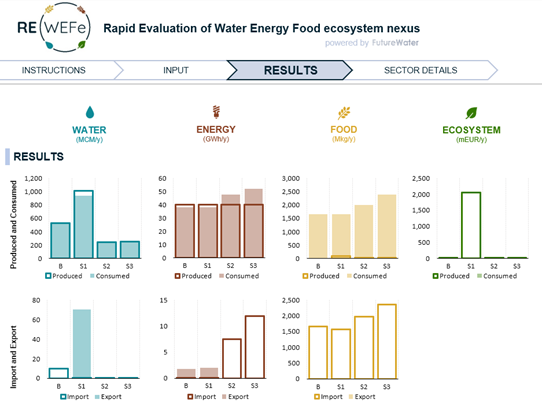
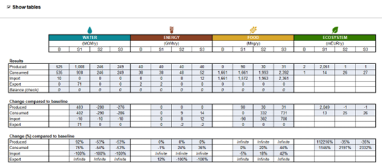
The REWEFe tool presents results in two tabs:
- Results Tab: Displays absolute and relative changes using bar graphs.
- Sectoral Details Tab: Provides a breakdown of sector-specific subcomponents, showing absolute values, percentage changes, and additional indicators like blue water stress and nutrient stress.
Outputs can be directly extracted from the tool for reports and presentations. Graphs and tables are ready-to-use, and additional customization is possible by exporting table data.
The REWEFe tool empowers practitioners worldwide to better understand and address the complex interdependencies within the WEFe nexus, paving the way for more sustainable and integrated solutions.