
![]()
Introduction
The Croptimal Tool supports sustainable agriculture by providing farmers and decision makers with precise, data-driven insights to optimize planting decisions and field management. By leveraging advanced weather, soil, and crop data, Croptimal provides crucial and localized information to answer the questions of (i) what, (ii) where and (iii) when to plant. In this manner, Croptimal helps to maximize agricultural productivity while improving food and income security for communities worldwide.
How It Works
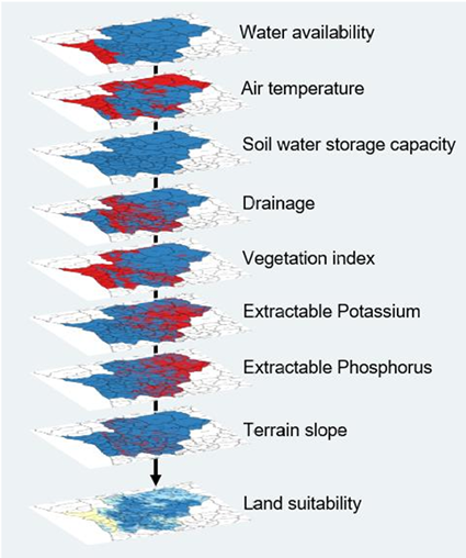
The Croptimal Tool integrates cutting-edge technology, including satellite-based data products and machine learning, into a robust crop growth model. High-resolution spatial data, such as rainfall, air temperature, crop evapotranspiration, soil properties, vegetation indices, and terrain slopes are analysed to evaluate land suitability at the regional to local level. Historical climate information is used to provide insights into crop-specific land suitability, and optional extensions include the coupling of seasonal weather forecast for a dynamic information service.
Key features include:
- Crop suitability thresholds: Identifying land conditions needed for optimal yields.
- High-resolution mapping: Land suitability maps created at 100-meter resolution.
- Seasonal insights: Recommendations for different cropping seasons (e.g., October-December, March-June, November-April).
Results
The tool provides location-specific planting recommendations through a user-friendly application. Suitability levels are classified into:
- Very suitable: Minimal limitations; minor field interventions needed.
- Suitable: Moderate limitations; standard field interventions required.
- Not ideal: Significant limitations; major interventions recommended.
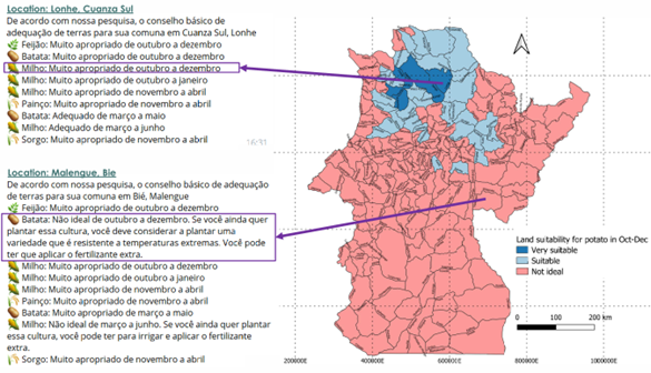
In cases where land is “Not ideal” for growing a particular crop during a season, farmers receive actionable field management advice. Recommendations may include using resilient crop varieties, irrigation strategies, drainage improvements, or applying fertilizers to address specific land limitations. These recommendations are tailored to the local agricultural context.
Initially developed for select regions and crops, the tool’s reach is continually expanding to include new locations and diverse crop types, as well as more advanced data layers. Croptimal has successfully been introduced in Angola and Egypt and is highly scalable to other regions.
Empowering Farmers Everywhere
The Croptimal Tool is a reliable, science-backed service that empowers farmers to make informed decisions. By providing actionable insights tailored to local conditions, it helps to achieve higher crop yields and more sustainable agricultural practices.